map Miles: today: 25.1/ total: 290.6
GPS Miles: 27.5/ total: 315.4
Today’s Miles Sponsored By: Peter, Niki
Woke to the stereo surround sound of an owl’s hoots echoing around the canyon walls. The full moon was still up and the air was still. I could just tell it was going to be a good day.
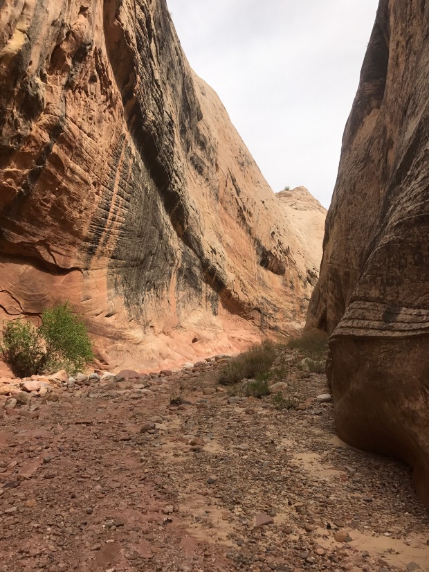
I packed during a spectacular sunrise and headed on my way off down Lower Muley Twist Canyon. This canyon is like none other that we’ve been in yet. The steep slickrock of the Waterpocket Fold surrounding us- it’s not a slot canyon, but it is narrow and high walled.
The canyon floor was solid too- hard packed gravel or straight on the slickrock, and since you’re in the canyon the whole time navigation wasn’t really a problem. It made the walking super simple.
The trail traverses the entire length of this canyon twisting and winding around the folds. I really enjoyed just being able to take it slow and look and around. Because of the high walls direct sunlight didn’t even enter the area until after 10am, and even then only in short patches, which kept the temperatures down, too. One thing I noticed were lots of little holes in the canyon walls that form almost like a spiderweb maze of connections.
I also found an old inscription on the wall. It looks like there was more to it that’s worn away. I’m so curious what these two folks story is.
My favorite parts of the canyon were when the bed went around a tight corner and formed a massive overhung alcove. Super super nifty.

This photo really doesn’t do the alcove justice. There were two or three more of these along the way.
About half way down the Twist I met Hot Shot and Freebird, two triple crowners who have been skipping around leapfrogging cars through the first few sections of the trail while they’re between their forest service seasons. They had done everything from Arches to Hole in the Rock Road and planned on finishing up this fall or next spring. We spent a long time chatting. It was so nice to have someone to talk with in person. I feel like sometimes my internal monologue can spiral out of control, and conversation helps keep that in check.
After parting from them, the canyon took a turn to the east directly into the Fold. It was the narrowest, highest walled section yet.
Suddenly we were out of the Fold and into the Grand Gulch! The stop to chat put me into my lunch break at the Muley Tanks (which were surprisingly difficult to find…I don’t think I even saw the sign!) a little later than I would have liked.
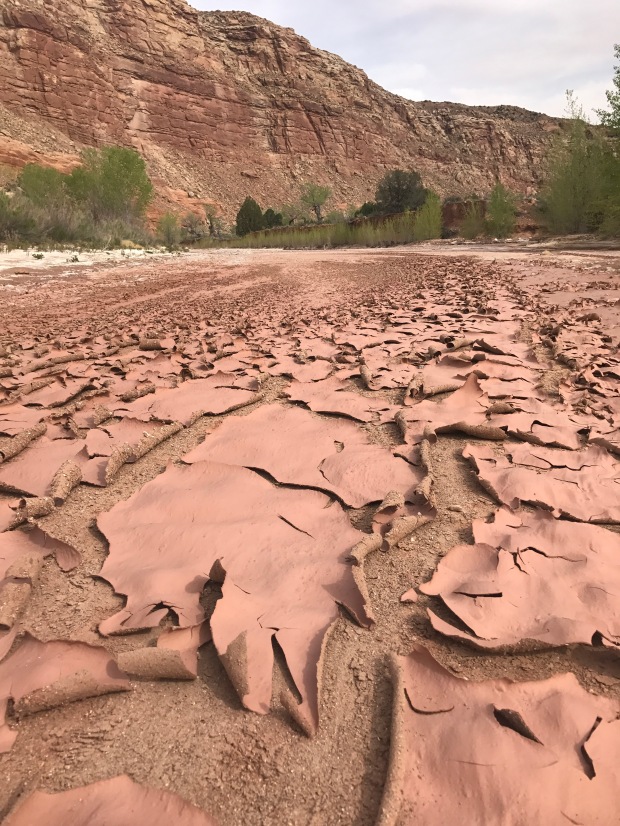
The Fold now stretched to my right and a huge cliffband stretched to the left, but the valley floor was much wider and the walking still was super easy. Halls Creek eventually would start flowing in the bed, but to start it was dry. I really enjoyed the crackling pealing dry red mud through much of this section.
With things breezing by, I noticed a little side trail out to Birnbaums Double Arch. The map said it was about a mile out, so I figured that seemed like a reasonable detour. I dropped my pack, grabbed a couple bars, a water bottle and my gps and headed out.
It was a nice little side canyon through a break in the Fold. About a half mile in I scrambled up a small rock, and turned a corner to find a narrow slot with a pool of water in it.
I could see cairns on the other side, so I figured this was the way. It had been a hot day anyway, so I didn’t mind getting a little wet. I waded in, the cool water feeling refreshing, but after a few steps I was waist deep….time to reevaluate. I climbed back out and tried to see if maybe I could take a high route over the rocks and avoid the water but that was a no go.
So I make a new plan. I empty my pockets onto a nearby rock, and only carry with me my gps (in a ziplock) and phone (in a waterproof case). I hold them above my head and slowly start in again, trying to stick to the right side wall. Hip deep, waist deep, chest deep, and suddenly I’m swimming.
Over my head.
Or I’m trying to swim while simultaneously trying to keep the electronics out of the water. Years of swim lessons kick in. I try to lay back and float and kick, but I can suddenly feel the heaviness of my sneakers. Kick kick kick and I’m back to chest deep water after what feels like way to long.
That was close…But do I learn my lesson? Well… maybe the depth was different on the other side, so before really thinking it out I head to the left side wall and try again. I do get further…about two thirds of the way across the pool, but ultimately the same result. Kicking, floating, flailing my way back to standing depth. The electronics both definitely take at least one dunking.
It’s not worth it. No double Arch for me today.
I’m soaked through and nervous that my gps or phone got water damaged and won’t be functional. Both have been pretty essential tools for better or worse- the phone doubling as my camera and gps, and the InReach as my tracker, and sos messenger. Fortunately they were both fine.
I wade back into the water one more time to pick up the cliff bar floating on the water’s surface that I’d forgotten to remove from my pocket (I realized later that I most have lost another one to the bottom of the pool too) and started the descent back to the main route. I was wet, but fortunately not cold. I was definitely a little shaken. It has me nervous for upcoming slots, and looking ahead to the Grand Canyon plunge pools….it’s just so hard to gauge water depth. At the same time I couldn’t help but thinking that my friend Bubbles probably would have loved it. (and made it to the Arch)
That adventure done for the day I continued to push down Halls Creek following the easy old cattle trails over the land. By continuing down the creek I’m taking another alternate route developed by Li Branfours that goes down Halls Creek and up Stevens Canyon to Coyote Gulch rather than walk 25 miles in the Escalante River which I’ve heard is just miserable.
I cruised into camp near the Halls Creek Narrows. It seems like a pretty popular place because I’ve seen two other tents set up nearby. I talked with one guy who gave me the details on the Narrows and it definitely sounds like something I want to do tomorrow.
In the meantime I have a lovely camp under a cottonwood. It’s so warm out tonight I don’t even need my puffy on! The frogs and crickets are serenading. I’m warm, I’m dry, and I’m alive. It was a good day.


Links to NPS description of the two hikes.
Click to access Lower-Muley-May15-low-res-locked-for-web-2.pdf
Click to access Halls-Creek-Narrows-May15-low-res-locked-for-web.pdf
LikeLike