
Map Miles: Today: 17.2/ Total: 65.6
GPS Miles Today: 20.7/Total: 76.7
Today’s Miles Sponsored By: Drop n Roll, Kristin, Lisa, Anonymous
I slept pretty fitfully again. While last nights mouse never returned and all my food (and stuff sacks) made it through the night, the wind picked up very heavily, and my hacking cough was about the worst it’s been. I picked up some Emergen-C in Moab, so hopefully that begins to help soon.
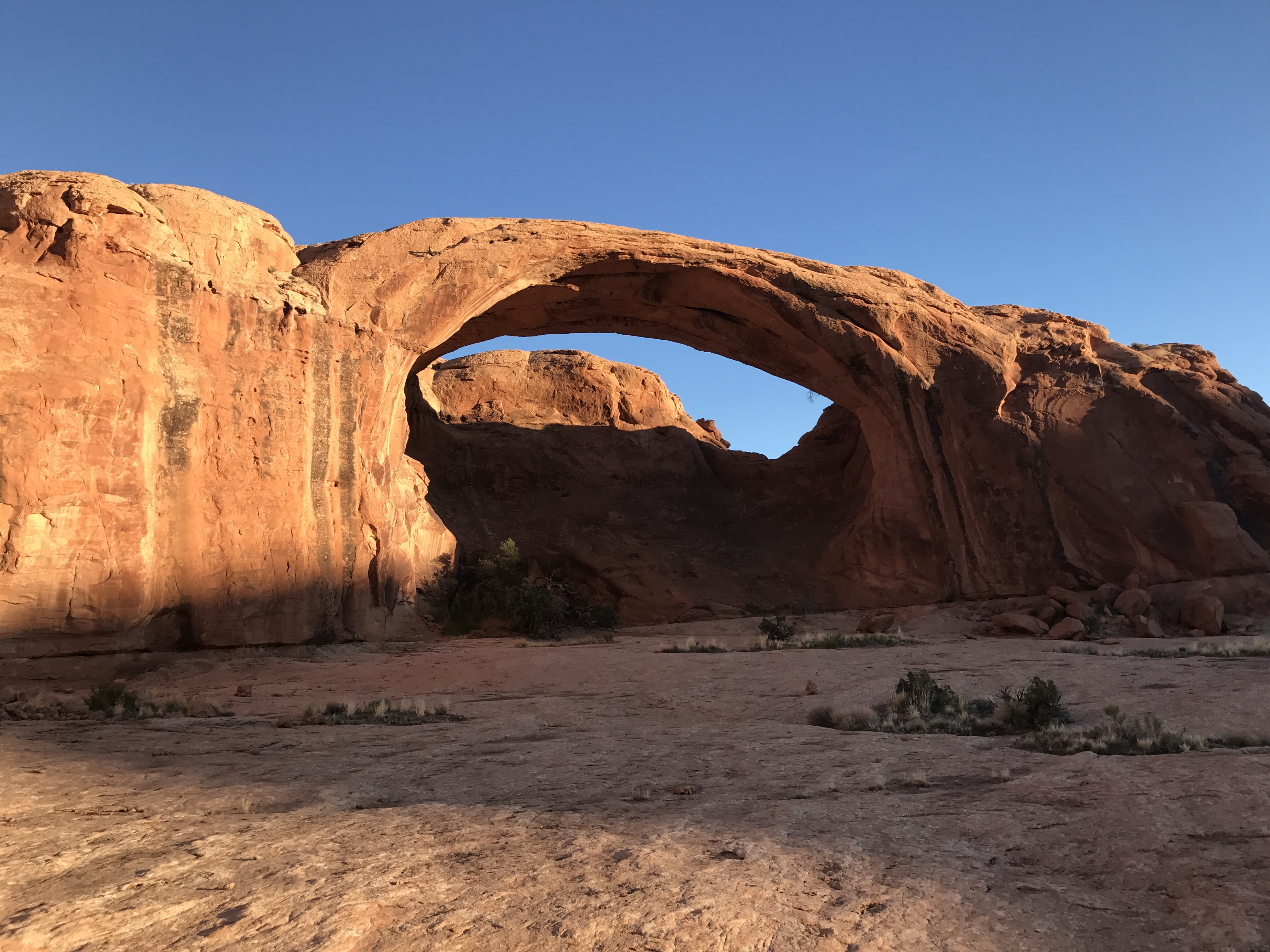
Pritchett Arch- worth the detour!
When I started walking though everything felt great! Feet, energy, everything seemed to be clicking! I zoomed up a short detour to Pritchett Arch and kept heading down the road. That was one of the great parts about today- 90% of it was on 4×4 roads ( if you can call those roads), dirt roads, and trail. But that other 10% was a doozy. The mesa that I was hiking on ended in a pretty sheer cliff over Kane Creek Road.

Kane Creek Cliffs…gotta go down!
There’s one section in the wall when you can descend, but it took a long time. The beginning, dropping from ledge to ledge actually went fairly easily, but the middle section went very slowly and involved 2 spots where I had to take off my pack- one class 4 with super awful exposure and one short class 5.fun with minimal exposure. One of the things that makes scrambling here so sketchy is that the rocks are not sturdy. I have stepped up/down many times onto what look like solid rock to only have it crack or split beneath my feet. I’m used to rocks not being secure in their placement, but never have seen them crack and crumble like this. It’s an important lesson to keep in mind for future sections of the trail.

My lunch spot under the shady cottonwoods looking back at the cliff I came down
Once down to the canyon floor i crossed over Kane Creek (picking up a bottle of the cow infested water) and began heading up Trough Springs Canyon where I had a relaxed lunch under the cooling cottonwoods.
The trail up from here to Hatch Mesa was super nice! Good tread and well cairned the whole way. It was built originally as a cattle trail to help them get from summer to winter pasture in the early 1900s.

Trough Springs Canyon with the La Sals above
I really enjoyed the climb, and then the wonderful walk along Hatch Mesa and the rolling green meadows at the top- with the La Sals absolutely popping.

Lydia Geopet loved the La Sals!
Beautiful meadows on the Mesa top.
At the top of the Mesa there was a BLM campground where I took a detour to utilize the listed bathroom, garbage, and water resources… except the water wasn’t turned on yet. Uh oh. I started the day with 4 quarts and added a 5th from Kane Springs as back up. Usually more than enough water for 1 plus days. However today I decided to drink a bit more than usual- smaller sips more frequently throughout the day. I put a little too much stock in that campground though. I could have gotten more from Kane Creek or from the Creek in Trough Springs Canyon- both had very good flow. Lesson learned.
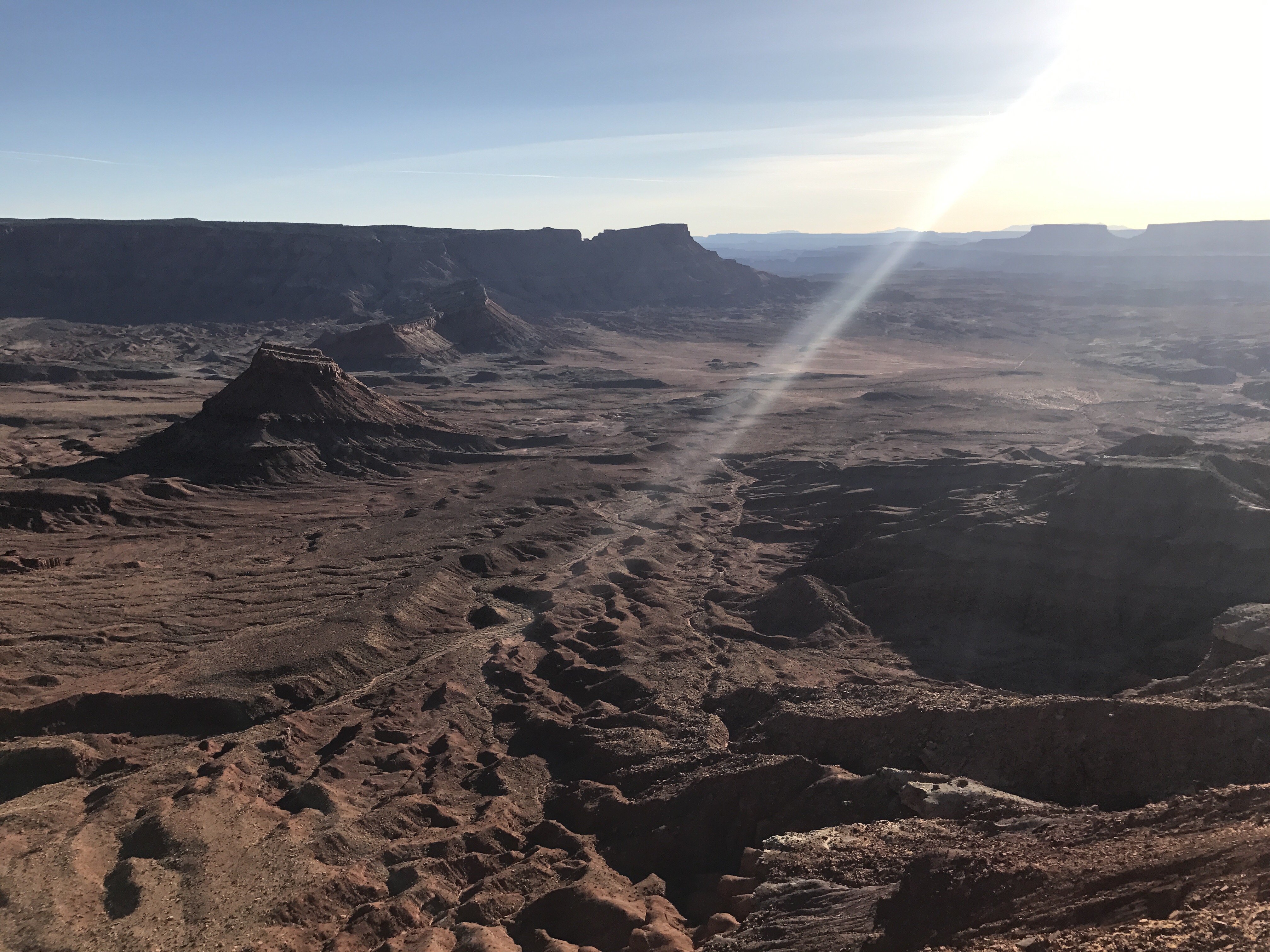
Lockheart Basin
So right now I have a water problem. I’m camped at the cliff edge above Lockheart Canyon tonight- a simply stunning location newly protected by the Bears Ears National Monument designation. I have a quarter of a quart of water left. The next guaranteed water is approximately 10-12 more miles up trail. I think once I get down the cliff I’ll be ok, but that part has me worried. I decided to save it for tomorrow morning so that I could do it on fresh legs and also so that I’d have more time- I wouldn’t be rushing dark. Well I’m not rushing dark now- just really bad dehydration. Keep your fingers crossed for me.

Prettiest campsite yet
